Saturday, June 14, 2025

The Life-Saving Breakthrough of 1923: How Insulin Transformed Diabetes Treatment and Global Health Forever

1923 – Insulin becomes generally available for use by people with diabetes.

The year 1923 stands as a pivotal moment in medical history, marking the widespread availability of insulin for the treatment of diabetes. This breakthrough transformed diabetes from a fatal disease into a manageable condition, offering hope and extended life to millions worldwide. The journey to this achievement is a compelling narrative of scientific curiosity, perseverance, and collaboration.

42,300+ Insulin Stock Photos, Pictures & Royalty-Free Images ...

Early Understanding of Diabetes and the Pancreas

Diabetes has been recognized for centuries, characterized by excessive thirst, frequent urination, and weight loss. Despite detailed clinical descriptions, its cause remained elusive. In the late 19th century, researchers began to suspect a link between the pancreas and diabetes. In 1869, German medical student Paul Langerhans identified clusters of cells within the pancreas, later named the islets of Langerhans. The function of these cells was unclear, but their discovery hinted at an internal secretion related to glucose metabolism.

In 1889, German physicians Oskar Minkowski and Joseph von Mering conducted experiments removing the pancreas from dogs, observing that the animals developed severe diabetes. This provided strong evidence of the pancreas's role in regulating blood sugar. Subsequent attempts to isolate the specific substance responsible were unsuccessful, as early pancreatic extracts were impure and caused adverse effects.

Breakthrough in Toronto: Discovery of Insulin

The turning point came in 1921 at the University of Toronto. Dr. Frederick Banting, a Canadian surgeon, hypothesized that isolating the internal secretion of the pancreas could treat diabetes. He approached Professor John Macleod, an expert in carbohydrate metabolism, who provided laboratory space and assigned Charles Best, a medical student, as his assistant.

Banting and Best conducted experiments by ligating the pancreatic ducts of dogs, causing the exocrine tissue to degenerate and leaving the islets intact. They extracted a substance from these islets and administered it to diabetic dogs, observing a significant reduction in blood sugar levels. This extract, initially termed "isletin," was later renamed insulin.

Recognizing the need for a more refined and pure form of insulin suitable for human use, Macleod enlisted biochemist James Collip to the team. Collip's expertise was instrumental in developing a purification process that produced a safer and more effective insulin extract.

First Human Trials and Immediate Impact

In January 1922, the first human trial of insulin was conducted on 14-year-old Leonard Thompson, who was critically ill with diabetes. The initial injection caused an allergic reaction due to impurities. Collip refined the extract further, and a second administration resulted in a remarkable improvement in Thompson's condition, with blood glucose levels returning to near-normal and a significant alleviation of symptoms.

The success of this trial garnered international attention, leading to a surge in demand for insulin. The University of Toronto, holding the patent for insulin, sought to make it widely available while maintaining quality control. They collaborated with pharmaceutical companies, notably Eli Lilly and Company in the United States, to scale up production. By October 1923, Eli Lilly had begun mass production of insulin under the brand name Iletin, making it accessible to patients across North America.

Global Expansion and Nobel Recognition

The impact of insulin was profound and immediate. Patients who were previously facing certain death began to recover, gaining weight and returning to normal activities. The medical community recognized the significance of this discovery, and in October 1923, the Nobel Prize in Physiology or Medicine was awarded to Banting and Macleod. In a gesture acknowledging the collaborative effort, Banting shared his prize money with Best, and Macleod shared his with Collip.

Internationally, the production of insulin expanded rapidly. In 1923, pharmaceutical laboratories in Germany began production under licenses from the Toronto Insulin Committee. Denmark and Austria followed suit the same year, with Hungary, Australia, and Argentina commencing production in 1924. This global effort ensured that insulin became available to diabetes patients worldwide.

Evolution of Insulin Therapy

Following its introduction, efforts focused on improving insulin formulations to extend its duration of action and reduce the number of daily injections required. In 1936, researchers developed a protamine-zinc insulin complex that prolonged insulin's effect. This was followed by Neutral Protamine Hagedorn (NPH) insulin in 1946, which became a standard intermediate-acting insulin.

The 1970s and 1980s witnessed the advent of recombinant DNA technology, enabling the production of human insulin. In 1982, the first biosynthetic human insulin, Humulin, was approved, offering a product identical to natural human insulin. Subsequent developments led to insulin analogs with tailored absorption and activity profiles, enhancing glycemic control and patient convenience.

Legacy and Ongoing Research

The discovery and commercialization of insulin in 1923 transformed diabetes management, turning a fatal disease into a chronic but manageable condition. This breakthrough has saved countless lives and continues to be a cornerstone of diabetes treatment.

Research into diabetes and insulin therapy persists, with efforts aimed at developing more effective delivery systems, such as insulin pumps and inhalable insulin, and exploring potential cures through pancreatic islet transplantation and stem cell therapy.

The journey of insulin from a laboratory discovery to a life-saving therapy exemplifies the profound impact of scientific innovation and collaboration on human health. The events of 1923 not only changed the prognosis for diabetes patients but also set a precedent for future medical breakthroughs.

Photo from iStock

Reserva de la Biosfera Tehuacán-Cuicatlán: Mexico’s UNESCO World Heritage Site of Unique Ecological and Cultural Significance

Tehuacán-Cuicatlán Biosphere Reserve: A Biodiversity and Cultural Heritage Treasure in Mexico

The Tehuacán-Cuicatlán Biosphere Reserve stands as one of Mexico's most remarkable protected areas, spanning an impressive 490,186 hectares across the southeastern state of Puebla and the northwestern region of Oaxaca . This vast territory, declared a UNESCO World Heritage Site in 2018 under the designation "Tehuacán-Cuicatlán Valley: originary habitat of Mesoamerica," represents a unique convergence of extraordinary biodiversity and profound cultural significance . The reserve derives its name from its two principal locations - Cuicatlán in Oaxaca and Tehuacán in Puebla, where the administrative offices are situated .

90+ Tehuacan Stock Photos, Pictures & Royalty-Free Images ...

What makes this reserve particularly exceptional is its dual recognition as a mixed World Heritage site, acknowledging both its natural wonders and its archaeological importance . This rare designation places it among only two such sites in Mexico, sharing this distinction with the Calakmul Biosphere Reserve in Campeche . The reserve's boundaries encompass 21 municipalities in Puebla and 30 in Oaxaca, creating a complex mosaic of ecosystems and human communities that have coexisted for millennia .

The Tehuacán-Cuicatlán Valley forms part of the Mesoamerican region and represents the richest biodiversity hotspot among all arid or semi-arid zones in North America . Its significance extends far beyond its borders, serving as a living laboratory for understanding plant domestication, ancient water management systems, and the evolution of human settlements in challenging environments. The reserve's serial property consists of three key components: Zapotitlán-Cuicatlán, San Juan Raya, and Purrón, all sharing a common buffer zone of approximately 344,932 hectares .

Geographical and Climatic Characteristics

The Tehuacán-Cuicatlán Biosphere Reserve occupies a dramatic landscape where the broad Tehuacán and Cuicatlán valleys stretch northwest to southeast, framed by the imposing Sierra Madre de Oaxaca to the east and the Sierra Mixteca to the west . This unique geographical positioning creates a rain shadow effect, with the mountain ranges blocking many rain clouds from surrounding regions and resulting in the area's distinctive semi-arid climate where average annual rainfall measures only 380-400 mm . The contrast between this arid environment and the humid climate of nearby Veracruz, just a few hours away, is particularly striking .

Hydrologically, nearly the entire reserve falls within the basin of the Salado River, which flows southeastward through the Tehuacán and Cuicatlán valleys . The Cuicatlán Valley also includes portions of the northwestward-flowing Grande River basin, where these two rivers converge to form the Santo Domingo River. This eventually joins the Papaloapan, one of Mexico's most significant rivers . The reserve's water systems are fed by numerous streams originating in the neighboring sierras, creating vital oases in this otherwise dry landscape .

Climatically, the region presents a fascinating diversity shaped by its varied topography. Approximately 73.57% of the reserve is classified as arid and semi-arid, 24.64% as temperate humid and subhumid, and 1.79% as warm humid and subhumid . This climatic variation contributes significantly to the area's exceptional ecological diversity. Visitors to the higher mountain areas frequently encounter thick fog that occasionally condenses into light drizzle, while the lower valleys experience warm semi-dry and warm semi-tropical conditions, particularly in the Cuicatec region .

The Sierra Madre de Oaxaca within the reserve consists of several sub-ranges, including the Sierra Zongolica in the north, Mazatec Sierra in the middle, and Sierra Juárez in the south . These mountains are characterized by spectacular karst topography cut by deep canyons, creating dramatic landscapes that alternate between towering peaks and expansive valleys . The reserve's elevation ranges create microclimates that support an astonishing variety of plant communities, from arid scrublands at lower elevations to cloud forests in the highest, wettest areas .

90+ Tehuacan Stock Photos, Pictures & Royalty-Free Images ...

Ecological Significance and Biodiversity

The Tehuacán-Cuicatlán Biosphere Reserve represents one of North America's most important biodiversity hotspots, recognized by IUCN for its concentration of endemic species, endangered species, and rare floristic specimens . Contrary to common assumptions about arid regions, this area boasts extraordinary biological richness, with studies identifying it as a distinct Floristic Province within the Mexican xerophytic Phytogeographical Region . The reserve supports representatives of an astonishing 70% of worldwide flora families and contains over 3,000 species of vascular plants, about 10% of which are endemic to the valley .

One of the reserve's most iconic ecological features is its spectacular columnar cacti forests, representing the highest concentration of such cacti in the world . Of the 70 columnar cactus species reported in Mexico, 45 are found in this central portion of the country . These towering cacti create unique landscapes alongside agaves, yuccas, and oaks, forming plant communities that are mostly endemic to Tehuacán-Cuicatlán . The reserve contains nine distinct plant communities dominated by columnar cacti, with species ranging from the massive "candelabro" (Pachycereus weberi) reaching up to 16 meters in height to the tiny endemic Mammillaria hernandezii measuring just five centimeters in diameter .

The reserve's vegetation forms a complex mosaic that includes xeric shrublands, tropical dry deciduous forest, pine forest, pine-oak woodlands, and cloud forest . The predominant flora in the Tehuacán Valley is scrubland or matorral, part of the Tehuacán Valley matorral ecoregion, comprising more than a third of recorded species . The Cuicatlán Valley features tropical dry deciduous forest, an outlier of the Balsas dry forests ecoregion, while the mountain slopes host oak and pine-oak forests connected to the Sierra Madre de Oaxaca pine-oak forests to the east and Sierra Madre del Sur pine-oak forests to the west .

The fauna of Tehuacán-Cuicatlán is equally impressive, particularly considering the arid conditions. The reserve hosts 134 species of terrestrial mammals (including two endemic to the valley), 353 bird species (nine endemic to Mexico), 18 fish species, 27 amphibian species, and 85 reptile species (20 of which are endemic) . Among these are notable species such as the threatened Green Macaw (Ara militaris), with the reserve containing one of Mexico's largest populations of this magnificent bird - over 100 individuals recorded since 2001 . Other significant fauna include the tepezcuintle (Aguti paca), tigrillo (Leopardus wiedii), river otter (Lontra longicaudis), lynx (Lynx rufus), and various species of deer and squirrels .

90+ Tehuacan Stock Photos, Pictures & Royalty-Free Images - iStock

The reserve's importance as a global center for agrobiodiversity cannot be overstated. It serves as a primary diversification center for numerous plant groups, particularly cacti, with 28 genera and 86 species represented, 21 of which are endemic . The area also maintains an unusually high number of threatened species, with about 38 listed under the IUCN Red List of Threatened Species . This extraordinary biodiversity results from millions of years of evolution in relative isolation, combined with the area's varied topography and microclimates that have allowed species to adapt and specialize in unique ways.

Archaeological and Cultural Heritage

The Tehuacán-Cuicatlán Valley holds immense significance as an archaeological site documenting an extraordinary 12,000 years of continuous human habitation . This lengthy occupation has left behind evidence of crucial technological developments, including some of the earliest known examples of plant domestication in the Americas and the continent's most ancient irrigation works . The valley's archaeological record reveals a complete sequence of human adaptations to arid environments, making it one of the most thoroughly documented cultural sequences in the Americas .

Among the most remarkable findings in the valley are fossilized remains of maize dating back to approximately 5000 BCE, discovered in Coxcatlán and other sites in the region . These archaeological treasures, associated with various stone tools, were found in mountain shelters where the exceptionally arid climate helped preserve organic materials that would have decomposed in more humid environments . The Tehuacán Valley is widely recognized as one of the primary locations where humans first domesticated maize, squash, and beans - the foundational crops of Mesoamerican agriculture .

The valley's ancient inhabitants developed sophisticated water management systems to cope with the arid conditions, creating what is considered the most diversified ancient irrigation complex on the continent . These technological innovations include an impressive array of canals, wells, aqueducts, dams, and terraces that allowed agricultural settlements to flourish in this challenging environment . The development of these water management systems represents one of humanity's major technological advances, alongside plant domestication, both of which originated in this valley .

Throughout its long history of human occupation, the Tehuacán-Cuicatlán Valley has been home to various Mesoamerican cultures, primarily of Otomanguean affiliation . Today, the reserve hosts communities from at least eight indigenous groups: Mixtecs, Cuicatecs, Ixcatecs, Nahuas, Chocholtecs, Popolocas, Chinantecs, and Mazatecs . These communities maintain profound traditional knowledge about the uses of local plants for food, medicine, construction, and crafts, knowledge accumulated over millennia of interaction with this unique environment .

The Popoloca people, who still inhabit the region, left behind stone ruins and tombs within the reserve's boundaries that date back centuries . These archaeological sites, though less known than major Mesoamerican cities like Monte Albán or Teotihuacan, provide invaluable insights into the daily lives and technological achievements of the valley's ancient inhabitants. Visiting these ruins requires local guides, as they are located in remote areas without marked trails .

The cultural landscape of Tehuacán-Cuicatlán represents a remarkable example of sustainable human-environment interaction. Traditional practices such as palm and clay crafts, salt extraction, and the sustainable harvesting of various fruits, seeds, leaves, and even insects continue to this day, providing economic opportunities while maintaining ecological balance . These activities, combined with growing ecotourism initiatives, demonstrate how conservation and human development can coexist harmoniously in this fragile ecosystem.

90+ Tehuacan Stock Photos, Pictures & Royalty-Free Images - iStock

Conservation History and Management

The Tehuacán-Cuicatlán region's journey to protected status involved several stages of recognition. Between 1995 and 1997, various portions of the area were cataloged as state conservation areas before being decreed as federal protected areas on September 18, 1998, by President Ernesto Zedillo Ponce de León . This established the Tehuacán-Cuicatlán Biosphere Reserve, incorporating earlier state-protected zones like the Cuicatlán Valley (1996), Tehuacán Valley, and Zapotitlán Valley (1997) as its core areas .

The reserve's management represents a pioneering example of community-based conservation in Mexico. According to the official declaration, local inhabitants are permitted to continue traditional economic activities provided they don't cause environmental deterioration . This approach recognizes that human communities have been an integral part of this landscape for millennia and that their traditional knowledge and practices contribute to the area's conservation .

In 2012, the site gained further international recognition when it was declared a Biosphere Reserve by UNESCO . The culmination of its global significance came on July 2, 2018, when it was inscribed on the UNESCO World Heritage List as a mixed (natural and cultural) site during the 42nd session of the World Heritage Committee . This dual designation acknowledges both the area's outstanding biodiversity and its archaeological importance in the development of Mesoamerican civilization .

The reserve faces numerous conservation challenges, including climate change, which poses significant threats to its delicate arid and semi-arid ecosystems . In response, management initiatives have implemented participatory water quality monitoring programs involving local communities, reserve leaders, and academics . These collaborative efforts aim to address environmental challenges while respecting the rights and needs of local populations.

Infrastructure development has played a complex role in the reserve's history. The construction of a superhighway in 1995 improved land connections between Oaxaca City and Mexico City (570 km apart) but also introduced new pressures on the ecosystem . Current management strives to balance accessibility for visitors and residents with the need to protect sensitive habitats and archaeological sites.

The reserve's administration operates under the principle of sustainable use of natural resources (IUCN category VI), allowing for human activities that don't compromise long-term ecological integrity . This model has made Tehuacán-Cuicatlán a reference point for how biodiversity conservation can generate opportunities for local people while protecting fragile ecosystems .

Visiting the Reserve

For travelers seeking to experience the wonders of Tehuacán-Cuicatlán, the reserve offers unique opportunities despite some accessibility challenges. Unlike conventional national parks with extensive trail systems, much of the reserve lacks developed roads or marked paths, making many areas inaccessible to casual visitors . The primary accessible area is the Jardín Botánico Helia Bravo Hollis, named after one of Mexico's pioneering biologists who specialized in studying the region's succulents .

The botanical garden, open daily from 9:00 to 17:00, serves as an excellent introduction to the reserve's flora . Entry fees are 90 pesos for foreigners and 45 pesos for Mexican nationals, with optional guided tours available (tips expected for guides) . The garden features nearly 200 plant species representative of the broader reserve, displayed in both cultivated settings at lower elevations and natural wild growth at higher levels .

Visitors can marvel at extraordinary specimens like the ancient beaucarnea (succulents that can live for hundreds of years), various agave species, and numerous cactus varieties including the towering tetecho columnar cacti that dominate the landscape . These giant cacti grow extremely slowly (about 10 meters in 140 years) and have wood-like interiors traditionally used by locals for various products . The garden's lookout tower offers spectacular views of the surrounding "cactus forest," a unique landscape found nowhere else on Earth .

For those interested in archaeology, the reserve contains Popoloca ruins accessible via a three-hour roundtrip hike with local guides (approximately 350 pesos) . Nearby, the town of Zapotitlán Salinas offers cultural experiences including a 16th-century church and restaurants serving traditional cactus-based cuisine, sometimes accompanied by salsa made with ants - a local delicacy . The area's salt flats, though not easily accessible without a vehicle or guide, represent another facet of traditional resource use in the region .

The best time to visit is during the dry season from November to April when conditions are most favorable . While public transportation options exist, renting a car provides greater flexibility for exploring the reserve's scattered attractions . A recommended three-day guided tour allows visitors to fully appreciate both the ecological and archaeological wonders of this extraordinary region .

Conclusion

The Tehuacán-Cuicatlán Biosphere Reserve stands as a testament to the incredible adaptability of both nature and human culture in the face of environmental challenges. Its unique combination of spectacular biodiversity, ancient archaeological sites, and living traditional cultures creates a landscape of unparalleled scientific and cultural value. As one of only two mixed World Heritage sites in Mexico, it represents a crucial conservation priority not just for the nation but for all humanity.

The reserve's columnar cacti forests, endemic species, and evidence of early plant domestication tell a story of evolutionary innovation spanning millions of years. Simultaneously, its ancient irrigation systems and archaeological remains document humanity's capacity to develop sophisticated solutions for thriving in arid environments. Perhaps most importantly, the continuing presence of indigenous communities maintaining traditional knowledge and sustainable practices offers hope for balanced coexistence between humans and nature in an era of environmental crisis.

For researchers, the reserve provides an open-air laboratory for studying biodiversity, climate change adaptation, and sustainable resource management. For visitors, it offers awe-inspiring landscapes and a profound connection to the deep history of Mesoamerican civilization. As climate change intensifies pressure on arid ecosystems worldwide, protecting and learning from places like Tehuacán-Cuicatlán becomes increasingly vital. This extraordinary biosphere reserve truly embodies the interconnectedness of natural and cultural heritage, preserving both biological evolutionary processes and the cultural traditions that have shaped this landscape over twelve millennia of human presence.

Photo from: iStock

Friday, June 13, 2025

Principal Component Analysis (PCA) and Its Application in Effective Dimensionality Reduction Techniques

Principal Component Analysis (PCA): A Comprehensive Exploration of Its Role and Application in Dimensionality Reduction

In the vast and dynamic field of data science and machine learning, the ability to extract meaningful patterns from complex, high-dimensional datasets is critical. With the growth of big data, researchers and data analysts are often confronted with datasets that include hundreds or even thousands of variables. While this abundance of information holds potential insights, it also poses significant challenges. High-dimensional data can be noisy, computationally expensive to process, and difficult to visualize or interpret. It is in this context that Principal Component Analysis (PCA) emerges as a powerful statistical technique, serving the critical function of dimensionality reduction while preserving as much information as possible.

500+ Machine Learning Pictures | Download Free Images on ...

PCA is widely used in exploratory data analysis, visualization, pattern recognition, and as a pre-processing step for machine learning algorithms. It transforms the original features into a new set of uncorrelated variables called principal components, ordered in such a way that the first few components retain most of the variation present in the original variables. This transformation allows researchers to reduce the number of variables without losing essential data characteristics, making PCA a cornerstone method in statistical learning and artificial intelligence.

To truly grasp PCA, one must delve into its mathematical foundation, understand the geometrical interpretation, examine how it reduces dimensionality, and explore its diverse applications across fields such as image processing, finance, biology, and natural language processing.

Theoretical Foundation of PCA

Principal Component Analysis was introduced by Karl Pearson in 1901 as a technique for summarizing data. Later formalized by Harold Hotelling in 1933, PCA is fundamentally a linear transformation. At its core, PCA involves finding a new coordinate system for the data such that the greatest variance by any projection of the data lies on the first coordinate (called the first principal component), the second greatest variance lies on the second coordinate, and so on.

To begin with, consider a dataset with multiple correlated variables. The aim is to convert these possibly correlated variables into a set of linearly uncorrelated variables. This transformation is achieved through an orthogonal projection of the data onto a lower-dimensional space, constructed by selecting the top eigenvectors of the covariance matrix of the data.

The mathematics behind PCA starts with data preprocessing. The first step involves centering the data, which means subtracting the mean of each variable so that the dataset has a mean of zero. This centering ensures that the principal components are not influenced by the original scale of measurement.

Following centering, the covariance matrix is computed. This matrix encapsulates the pairwise covariances between all variables in the dataset. Since PCA aims to find directions (principal components) that maximize variance, it uses this covariance matrix to determine where the spread of the data is most prominent.

The next step is to compute the eigenvalues and eigenvectors of the covariance matrix. Each eigenvector corresponds to a principal component, and its associated eigenvalue indicates the amount of variance in the data along that direction. The eigenvectors are sorted by their eigenvalues in descending order. The top eigenvectors form the principal component axes, and projecting the data onto these axes transforms it into a new set of variables that are uncorrelated and ordered by importance.

Geometric Intuition Behind PCA

Understanding PCA geometrically helps demystify its operations. Imagine a simple 2D dataset with two variables, X and Y, that are correlated. The data points may form an elliptical cloud stretching diagonally across the X-Y plane. The principal component analysis attempts to identify a new set of axes such that the first axis (PC1) lies along the direction of the maximum variance, i.e., the direction in which the data is most spread out.

This new axis is a linear combination of X and Y and is determined by the eigenvector with the largest eigenvalue. The second axis (PC2) is orthogonal to the first and accounts for the second-largest variance. The key idea is to project the data onto this new coordinate system. By keeping only the first one or two principal components, one can reduce the number of variables while preserving as much of the original variance as possible.

In three or more dimensions, this concept generalizes easily. PCA rotates the dataset so that the axes align with the directions of maximum variance. This projection simplifies the structure of the data and reveals the latent features that explain observed patterns.

Dimensionality Reduction Using PCA

One of the most important applications of PCA is dimensionality reduction. As datasets grow in complexity and volume, dimensionality becomes a curse rather than a blessing. High-dimensional datasets often suffer from redundancy, where many variables are correlated and convey overlapping information. Furthermore, algorithms operating in high-dimensional space tend to perform poorly due to the curse of dimensionality, a phenomenon where the volume of space increases so rapidly that data becomes sparse, and traditional algorithms fail to generalize.

PCA mitigates these problems by reducing the number of dimensions while retaining as much of the data's variability as possible. The dimensionality reduction process typically involves the following steps:

  1. Compute the covariance matrix of the centered data to understand how the variables relate to each other.

  2. Calculate eigenvectors and eigenvalues of the covariance matrix to identify principal components.

  3. Sort the eigenvectors in order of decreasing eigenvalues, which correspond to the amount of variance captured.

  4. Select the top k eigenvectors that account for a desired amount of total variance (e.g., 95%).

  5. Project the data onto the new subspace defined by these top k eigenvectors.

This projection results in a dataset with reduced dimensions that preserves the most significant features of the original data. Notably, the choice of how many principal components to keep is crucial. A common approach is to plot the explained variance ratio as a function of the number of components and use the elbow method to identify the optimal number of components that balance simplicity and fidelity.

Advantages of Using PCA

PCA offers several advantages that make it a preferred method for dimensionality reduction and feature extraction. First and foremost, it reduces computational complexity. Machine learning algorithms often perform faster and better with fewer features, especially if those features are uncorrelated and noise-free.

Secondly, PCA improves model interpretability by condensing the data into its most informative components. Although the new components are linear combinations of the original variables, they often uncover latent structures that are not obvious in the raw data.

Thirdly, PCA helps to eliminate multicollinearity among variables. Many statistical models assume independence among predictors. PCA transforms correlated variables into a set of uncorrelated components, satisfying this requirement.

Moreover, PCA aids in data visualization. By reducing multidimensional data to two or three principal components, it becomes possible to plot and visually explore complex datasets, cluster structures, and patterns that would otherwise remain hidden.

Limitations and Pitfalls of PCA

Despite its strengths, PCA is not without limitations. One of the major drawbacks is that PCA is a linear method. It assumes that the principal components can capture the data structure through linear combinations of variables. Consequently, it may fail to uncover patterns in datasets with non-linear relationships. For such cases, kernel PCA or non-linear manifold learning methods like t-SNE and UMAP may perform better.

Another limitation is interpretability. While PCA reduces data to a smaller set of variables, these components are often abstract and do not correspond to real-world variables. This abstraction can make it difficult for analysts to interpret or explain the results in practical terms.

Furthermore, PCA is sensitive to scaling. Variables with larger scales can dominate the principal components. Therefore, standardization (transforming variables to have unit variance and zero mean) is essential before applying PCA.

Lastly, PCA assumes that directions of maximum variance are the most important, which might not always hold. In supervised learning contexts, this assumption may conflict with the goal of maximizing predictive power, since PCA ignores target labels.

Applications of PCA in Real-World Scenarios

PCA finds applications in numerous domains. In image processing, PCA is used for face recognition. The famous eigenfaces method applies PCA to a set of face images to identify the principal components (features) that distinguish one face from another. These components can then be used to represent and recognize faces in a low-dimensional space.

In genomics and bioinformatics, PCA is used to analyze gene expression data. High-throughput sequencing generates vast amounts of data with thousands of gene expressions. PCA helps to identify clusters, outliers, and principal gene patterns in complex biological data.

In finance, PCA is used for risk analysis and portfolio management. Financial assets often exhibit correlated behavior. PCA can decompose market returns into principal factors that explain overall variance. This factor model aids in diversification and hedging strategies.

In natural language processing, PCA assists in word embedding and topic modeling. Word embeddings, which represent words in continuous vector space, often have high dimensions (e.g., 300). PCA can be used to reduce these embeddings for visualization or to improve model performance.

In ecology, PCA helps in species distribution modeling and environmental studies. It reduces the number of environmental variables while preserving the most critical gradients that affect species distribution.

Variants and Extensions of PCA

Over the years, researchers have developed various extensions of PCA to address its limitations. Kernel PCA is one such variant that uses kernel methods to capture non-linear structures in the data. By implicitly mapping the data into a higher-dimensional space, kernel PCA can reveal non-linear patterns that standard PCA misses.

Sparse PCA introduces sparsity into the principal components, ensuring that each component depends on only a few original variables. This modification enhances interpretability, especially in high-dimensional settings such as genomics.

Robust PCA is another variant designed to handle outliers and noise. Unlike standard PCA, which can be sensitive to extreme values, robust PCA separates the low-rank structure of the data from sparse noise.

Incremental PCA is tailored for large-scale or streaming data. It processes data in batches, updating the principal components incrementally rather than computing them all at once. This method is especially useful when working with memory constraints or real-time data.

Conclusion

Principal Component Analysis remains one of the most powerful and versatile tools in the data scientist’s arsenal. Its elegance lies in its ability to reduce dimensionality, eliminate redundancy, and reveal the underlying structure of data through linear transformation. Whether applied to gene expression profiles, financial market movements, digital images, or text embeddings, PCA offers a mathematically sound and computationally efficient means of extracting the most informative aspects of complex datasets.

Yet, as with any method, PCA must be used thoughtfully. Understanding its assumptions, limitations, and proper application is key to extracting genuine insights. With the ever-growing demand for interpretable, scalable, and accurate data analysis, PCA will likely continue to play a central role in bridging the gap between high-dimensional data and human understanding.

By transforming overwhelming data into insightful patterns, Principal Component Analysis exemplifies the very essence of modern data science: simplifying complexity while amplifying meaning.

Photo From: Unsplash

Mauna Loa Volcano: Geological Formation, Historical Eruptions, Monitoring Efforts, Hazards, and Cultural Significance Explained

Mauna Loa Volcano: Geological Formation, Historical Eruptions, Cultural Significance, Monitoring, Hazards, and Future Outlook

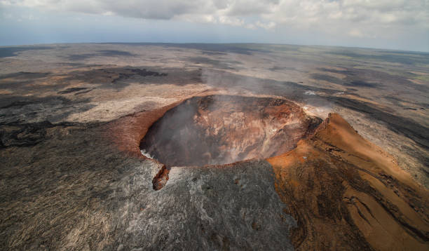
Mauna Loa, whose name means "Long Mountain" in Hawaiian, is the largest active volcano on Earth by both mass and volume. Located on the Big Island of Hawaiʻi, it is a quintessential shield volcano, characterized by broad, gently sloping sides formed by highly fluid basaltic lava flows. Rising 13,681 feet (4,170 meters) above sea level and extending 30,000 feet (9,144 meters) from its base on the ocean floor, Mauna Loa surpasses Mount Everest in total height when measured from its underwater foundation. This colossal volcano has played a pivotal role in shaping the Hawaiian archipelago and continues to be a focal point for geological research, cultural significance, and volcanic hazard monitoring.

430+ Mauna Loa Stock Photos, Pictures & Royalty-Free Images ...

Geological Formation and Structure

Mauna Loa was formed by the Hawaiian hotspot, a plume of molten rock rising from deep within the Earth’s mantle. As the Pacific tectonic plate moved northwestward over this stationary hotspot, a chain of volcanic islands was created, with Mauna Loa being one of the youngest and most active. The volcano likely began erupting underwater around 700,000 years ago and emerged above sea level approximately 400,000 years ago.

The structure of Mauna Loa is dominated by its summit caldera, Mokuʻāweoweo, which spans 6.2 by 2.5 km (3.9 by 1.6 mi) and consists of three overlapping pit craters. The caldera floor lies between 50 and 170 meters (164–558 feet) below its rim and has undergone multiple collapses and refilling events over millennia. The volcano also features two primary rift zones—the Northeast Rift Zone (NERZ) and the Southwest Rift Zone (SWRZ)—which extend from the summit and serve as conduits for magma during eruptions.

Mauna Loa’s magma is silica-poor and highly fluid, resulting in effusive (non-explosive) eruptions that produce extensive lava flows rather than violent explosions. However, historical evidence suggests that explosive eruptions did occur between 300 and 1,000 years ago, likely due to interactions between magma and groundwater.

430+ Mauna Loa Stock Photos, Pictures & Royalty-Free Images ...

Historical Eruptions and Impact

Mauna Loa has erupted 34 times since 1843, with an average interval of about five years between eruptions. However, the period between its 1984 and 2022 eruptions—38 years—was the longest recorded quiescence in its documented history.

Notable Eruptions:

  • 1868 Eruption – One of the most destructive in Hawaiian history, this event began with summit activity on March 27, followed by a massive M7.9 earthquake on April 2, which triggered landslides, a tsunami, and significant damage. Lava flows from the Southwest Rift Zone reached the ocean in just 3.5 hours, covering 9 square miles (24 km²) of land. New research suggests that the summit caldera may have collapsed during this eruption, similar to Kīlauea’s 2018 collapse, though historical records are limited.

  • 1950 Eruption – This SWRZ eruption produced fast-moving lava flows that reached the sea within hours, destroying villages in South Kona.

  • 1984 Eruption – Lava flows advanced toward Hilo but stopped just 4 miles short of the city.

  • 2022 Eruption – After 38 years of dormancy, Mauna Loa erupted on November 27, 2022, with fissures opening in Mokuʻāweoweo before migrating to the NERZ. Lava flows traveled 12.1 miles (19.5 km) and covered 16.5 square miles (42.7 km²), stopping 1.7 miles short of Saddle Road (Daniel K. Inouye Highway). The eruption lasted until December 13, 2022, and was closely monitored due to its potential threat to infrastructure, including the Mauna Loa Observatory, which lost power when lava cut its access road.

430+ Mauna Loa Stock Photos, Pictures & Royalty-Free Images ...

Monitoring and Hazards

The USGS Hawaiian Volcano Observatory (HVO) has monitored Mauna Loa since 1912, using a network of seismometers, tiltmeters, GPS stations, and satellite radar (InSAR) to detect magma movement and ground deformation.

Key Monitoring Observations from the 2022 Eruption:

  • Seismic Activity: A swarm of shallow earthquakes beneath the summit began around 10:20 p.m. on November 27, signaling magma ascent.

  • Ground Deformation: Tiltmeters recorded over 100 microradians of inflation at the summit before rapid deflation once the eruption began.

  • Summit Subsidence: GPS data showed the caldera floor sank nearly 40 cm (16 inches) as magma drained from the summit reservoir.

Mauna Loa’s eruptions pose significant hazards due to their potential for fast-moving lava flows, which can threaten communities like Hilo and Hawaiian Ocean View Estates. Additionally, volcanic gases (e.g., sulfur dioxide) and ash emissions can impact air quality.

Cultural and Ecological Significance

Mauna Loa holds deep cultural importance in Hawaiian traditions as the domain of Pele, the goddess of fire and volcanoes. The volcano’s lava flows have also shaped Hawaiʻi’s ecosystems, creating new land while burying forests and altering landscapes.

The Mauna Loa Observatory, located near the summit, is a critical facility for atmospheric research, particularly in tracking global CO₂ levels via the Keeling Curve. The 2022 eruption disrupted these measurements temporarily, forcing scientists to relocate instruments to Maunakea until power was restored.

Future Eruptions and Long-Term Outlook

Mauna Loa will undoubtedly erupt again, given its history of frequent activity. While the volcano is currently in a period of recovery and magma recharge, HVO continues to monitor for signs of renewed unrest.

In the long term (over millions of years), Mauna Loa will eventually drift away from the Hawaiian hotspot, becoming extinct like its neighbors Kohala and Mauna Kea. Erosion will gradually reduce its height, transforming it into a deeply dissected island similar to Kauaʻi.

Conclusion

Mauna Loa is a dynamic and awe-inspiring force of nature, embodying the raw power of volcanic activity. Its eruptions have shaped the Hawaiian landscape, influenced scientific understanding of volcanism, and posed both risks and opportunities for local communities. As monitoring technology advances, scientists can better predict future activity, but the volcano’s unpredictability ensures that it will remain a subject of fascination and respect for generations to come.

For those visiting Hawaiʻi, Mauna Loa offers unparalleled opportunities to witness geology in action—from hiking its rugged slopes to observing the aftermath of its latest eruption. Whether viewed as a scientific marvel or a cultural icon, Mauna Loa stands as a testament to the ever-changing nature of our planet.

Photo from: iStock

Thursday, June 12, 2025

How much impact does DeepSeek's AI technology have on the global market?

How much impact does DeepSeek's AI technology have on the global market?

DeepSeek, a Chinese artificial intelligence (AI) startup, has rapidly emerged as a formidable player in the global AI landscape. Its innovative approaches and cost-effective strategies have not only challenged established Western tech giants but also prompted significant shifts in market dynamics, investment strategies, and technological development worldwide.

 Logo Deepseek Ai Background PNG Transparent Background, Free ...

Introduction to DeepSeek

Founded in 2023 by Liang Wenfeng in Hangzhou, Zhejiang, DeepSeek is owned and solely funded by the Chinese hedge fund High-Flyer. The company focuses on developing open-source large language models (LLMs) and has made significant strides in AI research and application. DeepSeek's flagship model, DeepSeek-R1, performs tasks at a level comparable to OpenAI's ChatGPT, despite being developed at a fraction of the cost. The model was trained in approximately 55 days at a cost of around $5.58 million, significantly lower than the investments made by Western counterparts.

Market Disruption and Financial Impact

The release of DeepSeek's AI models has had profound effects on global financial markets. On January 27, 2025, major U.S. tech stocks, including Nvidia, Microsoft, and Tesla, experienced a significant downturn, collectively losing about $1 trillion in market value. Nvidia, in particular, saw a dramatic 17% drop, erasing $589 billion in market value—the largest single-day loss in history. This market upheaval was largely attributed to DeepSeek's emergence and its cost-effective AI solutions, which raised concerns about the efficiency and spending of U.S. tech giants on AI research.

Technological Advancements and Cost Efficiency

DeepSeek's approach to AI development challenges the prevailing notion that massive investments and extensive use of high-end processors are necessary. The company developed its AI models using significantly fewer resources compared to its peers. For instance, while leading AI companies train their chatbots with supercomputers using as many as 16,000 integrated circuits, DeepSeek claims to have needed only about 2,000 specialized computer chips, specifically the H800 series from Nvidia. This frugal approach not only reduces costs but also democratizes AI development, making it more accessible to a broader range of players beyond China's borders.

Strategic Implications and Global AI Race

DeepSeek's rise is reflective of China's known disruption strategy—undercutting Western companies with low-cost alternatives. This approach has been previously observed in markets such as commodities and electric vehicles. DeepSeek's success redefines the AI race landscape, challenging U.S. dominance and illustrating how attempts to curb China's tech progress, such as chip export restrictions, may instead foster innovation and competitiveness within China.

Open-Source Model and Ethical Considerations

One of the most striking aspects of DeepSeek is its commitment to openness. Unlike most of its competitors, DeepSeek has chosen to make its model free to access and modify under one of the most open open-source licenses. This decision could radically transform the AI ecosystem by enabling a large number of players to benefit from this technological breakthrough. However, the entry of DeepSeek also raises concerns about ethical AI development and sustainable models. The open-source nature of DeepSeek's models necessitates a discussion on the responsible use and potential misuse of AI technologies.

Global Reactions and Future Outlook

The global response to DeepSeek's advancements has been mixed. While some view this development as a dire warning for the U.S. to accelerate its AI efforts, others see it as a beneficial innovation that could lead to more affordable AI solutions. Experts debate the long-term significance of DeepSeek's accomplishments, with discussions encompassing economic impacts, national security considerations, and the evolution of industry competition and technological advancement.

Conclusion

DeepSeek's emergence has undeniably disrupted the global AI market. Its cost-effective and open-source approach challenges established norms and compels industry leaders to reassess their strategies. As the AI landscape continues to evolve, DeepSeek's impact serves as a catalyst for innovation, competition, and critical discussions on the future of artificial intelligence.

Golden Chains: How 12 Nations Are Locked Into Mining-Dominated Economies – And the Risks They Face

Countries That Rely Heavily on Mining Exports: A Deep Dive into Economic Dependence

Mining plays a crucial role in the global economy, providing essential raw materials for industries ranging from technology to construction. However, some nations depend so heavily on mineral exports that their entire economic stability is tied to the fluctuations of global commodity prices. 

11,845 Copper Gold Mineral Royalty-Free Photos and Stock ...

This article explores the countries where mining contributes to over 60% of total exports, analyzing their key minerals, regional trends, and the economic implications of such heavy reliance.

The Dominance of Mining in National Economies

The list of countries most dependent on mining exports is dominated by African nations, with a few from the Americas and Asia. The data, averaged between 2019 and 2021 and published in 2023 by the UN Trade & Development and The Observatory of Economic Complexity, reveals a striking concentration of economic activity around a single mineral in each case.

1. Botswana: Diamonds Fueling 92% of Exports

Botswana stands at the top of the list, with diamonds accounting for a staggering 92% of its exports. The country’s partnership with De Beers has made it one of the world’s leading diamond producers. While this has brought significant wealth, it also leaves Botswana vulnerable to diamond price volatility and shifts in global demand, particularly from major markets like China and the U.S.

2. Guinea, Mali, Burkina Faso: West Africa’s Golden Trio

West Africa is a gold powerhouse, with Guinea (87%), Mali (85%), and Burkina Faso (84%) all relying overwhelmingly on gold exports. These nations have seen a surge in mining investments, particularly from Chinese and Russian companies. However, political instability, artisanal mining challenges, and environmental concerns pose risks to long-term sustainability.

3. Suriname & Guyana: South America’s Emerging Gold Hubs

In the Americas, Suriname (83%) and Guyana (64%) are increasingly dependent on gold exports. Guyana, in particular, has seen a boom due to new discoveries, but weak regulatory frameworks raise concerns about illegal mining and environmental degradation.

4. Zambia & DRC: Africa’s Copper Giants

Central and Southern Africa are critical to global copper supply, with Zambia (79%) and the Democratic Republic of Congo (DRC) (77%) leading the way. The DRC alone produces over 70% of the world’s cobalt, a key mineral for electric vehicle batteries. However, corruption, poor labor conditions, and geopolitical tensions (especially in the DRC) create instability.

5. Mauritania & Namibia: Diverse but Still Dependent

Mauritania’s economy is 66% reliant on gold, while Namibia derives 61% of its exports from diamonds. Both nations have tried diversifying—Mauritania into iron ore and Namibia into uranium—but mining remains the backbone of their trade.

6. Kyrgyzstan & Peru: The Asian and American Exceptions

Outside Africa, Kyrgyzstan (62%) and Peru (61%) are the only countries on this list. Kyrgyzstan’s gold mining sector has faced political backlash, while Peru’s copper industry is vital for global supply chains but often disrupted by protests and regulatory hurdles.

Economic Risks of Over-Reliance on Mining

Vulnerability to Price Volatility

Countries dependent on a single mineral are at the mercy of global price swings. For example, when copper prices dropped in 2015-2016, Zambia’s economy suffered severe setbacks. Similarly, a decline in diamond demand could devastate Botswana.

The "Resource Curse" Phenomenon

Many mineral-rich nations fall victim to the "resource curse", where wealth from mining leads to corruption, inequality, and weak governance rather than broad economic development. The DRC, despite its vast mineral wealth, remains one of the world’s poorest countries.

Environmental and Social Challenges

Mining often leads to deforestation, water pollution, and displacement of communities. In Suriname and Guyana, illegal gold mining has caused mercury contamination, while in the DRC, cobalt mining is linked to child labor.

Geopolitical Tensions

Minerals like copper, gold, and diamonds are strategic resources, leading to foreign interference. China’s dominance in African mining has sparked tensions with Western nations, while internal conflicts (like in Burkina Faso and Mali) disrupt production.

Is Diversification Possible?

Some countries, like Botswana, have used mining revenues to invest in education and tourism. Namibia is expanding into renewable energy. However, breaking free from mining dependence is difficult due to entrenched economic structures and lack of alternative industries.

Conclusion

While mining brings immediate revenue, over-reliance on mineral exports creates long-term vulnerabilities. The countries listed here must balance short-term gains with sustainable economic strategies to avoid the pitfalls of the resource curse. As global demand for critical minerals grows—especially for the green energy transition—the stakes for these nations have never been higher.

Photo from Shutterstock

Sources: Elements (on X)

  • UN Trade & Development

  • The Observatory of Economic Complexity

  • World Bank Reports on Mining Economies

The Vasa Museum in Stockholm, Sweden: A Voyage Through Time and Preservation

The Vasa Museum: A Maritime Marvel in Stockholm

The Vasa Museum, located in Stockholm, Sweden, is one of the most unique and fascinating maritime museums in the world. It is dedicated to the preservation and display of the Vasa, a 17th-century warship that sank on its maiden voyage in 1628 and was salvaged over 300 years later in remarkably good condition. The museum not only showcases the ship itself but also provides deep insights into Sweden’s naval history, shipbuilding techniques, and life during the early modern period. With over a million visitors annually, the Vasa Museum stands as a testament to Sweden’s rich maritime heritage and the incredible efforts of archaeologists and conservators who brought this historical treasure back to life.

170+ Vasa Museum Stock Photos, Pictures & Royalty-Free ...

The Historical Background of the Vasa

To fully appreciate the significance of the Vasa Museum, one must first understand the history of the Vasa ship itself. The early 17th century was a time of great power struggles in Europe, and Sweden, under the rule of King Gustav II Adolf (Gustavus Adolphus), sought to establish itself as a dominant force in the Baltic region. The Thirty Years' War (1618–1648) was raging, and Sweden needed a strong navy to protect its interests and expand its influence.

In 1625, the Swedish monarch commissioned the construction of a grand warship that would symbolize the nation’s military might. The Vasa, named after the ruling Vasa dynasty, was designed to be one of the most powerful ships of its time. The king demanded a ship with two gun decks, carrying 64 bronze cannons, and adorned with elaborate carvings depicting biblical, mythological, and royal symbols. The shipbuilders, led by Dutch master shipwright Henrik Hybertsson, worked tirelessly to meet the king’s ambitious vision.

However, the construction of the Vasa was fraught with difficulties. Hybertsson fell ill and died before the ship was completed, leaving his assistant to oversee the final stages. Moreover, the king frequently altered the ship’s design, demanding additional ornamentation and firepower, which made the vessel top-heavy. Despite concerns from experienced sailors about its stability, the Vasa was launched on August 10, 1628, in front of a crowd of spectators in Stockholm harbor.

Tragically, the ship’s maiden voyage lasted only about 1,300 meters (less than a mile). A strong gust of wind caused the Vasa to tilt dangerously, water rushed in through the open gunports, and the ship sank within minutes. Between 30 to 50 of the 150 people on board perished in the disaster. An official inquiry was held, but no one was found guilty; the blame was indirectly placed on the deceased shipbuilder and the king’s unrealistic demands.

170+ Vasa Museum Stock Photos, Pictures & Royalty-Free Images - iStock |  Gamla stan, Stockholm, Sognefjord

The Rediscovery and Salvage of the Vasa

For centuries, the Vasa lay forgotten at the bottom of Stockholm’s harbor, buried in mud that preserved its wooden structure from decay. In the 1950s, amateur archaeologist Anders Franzén became obsessed with finding the wreck. Using historical records and a simple coring device, he located the ship in 1956. The Swedish government, recognizing the immense historical value of the find, launched one of the most ambitious salvage operations in maritime history.

Between 1957 and 1961, divers painstakingly prepared the Vasa for recovery by tunneling under the hull and attaching lifting cables. On April 24, 1961, after 333 years underwater, the Vasa was raised from the depths in a dramatic operation watched by millions on live television. The ship was remarkably intact, with much of its original structure, sculptures, and artifacts preserved due to the cold, brackish waters of the Baltic Sea, which deterred wood-eating organisms.

Once salvaged, the Vasa underwent an extensive conservation process. To prevent the wood from cracking as it dried, the ship was sprayed with polyethylene glycol (PEG) for 17 years. This treatment replaced the water in the wood’s cells, stabilizing the structure. The conservation efforts were groundbreaking and set new standards for maritime archaeology.

Vasa Museum Stockholm Warship - Free photo on Pixabay

The Vasa Museum: A Home for the Resurrected Ship

After years of preservation work, the Swedish government decided to build a permanent museum to house the Vasa. The ship was initially displayed in a temporary structure called Wasavarvet (The Vasa Shipyard), but as public interest grew, plans for a dedicated museum took shape. In 1990, the Vasa Museum opened on Djurgården Island in Stockholm, designed by architects Marianne Dahlbäck and Göran Månsson. The building’s striking copper-roofed structure was inspired by the ship’s masts and sails, creating a fitting tribute to the vessel inside.

The museum was carefully constructed around the Vasa, ensuring that the ship could remain in a climate-controlled environment to prevent further deterioration. Today, the Vasa is the centerpiece of the museum, displayed in a massive hall where visitors can view it from multiple levels, providing perspectives from the keel to the towering stern.

Exploring the Vasa Museum

A visit to the Vasa Museum is a journey back in time, offering an immersive experience into 17th-century naval warfare, craftsmanship, and daily life. The museum is divided into several exhibition areas, each providing unique insights into different aspects of the Vasa and its historical context.

The Vasa Ship Itself

The main hall houses the Vasa in all its grandeur. The ship stands nearly intact, with its intricate carvings, gun decks, and masts visible. The sheer size of the vessel (69 meters long and 52 meters tall) is awe-inspiring, and the detailed sculptures—featuring lions, biblical figures, and Roman emperors—reflect the artistic and political ambitions of the Swedish monarchy.

The Salvage and Conservation Exhibits

One of the museum’s most fascinating sections details the salvage operation and the scientific efforts to preserve the Vasa. Visitors can see original artifacts recovered from the ship, including clothing, tools, and personal belongings of the crew. Interactive displays explain the challenges of raising and conserving a 300-year-old wooden ship.

Life on Board the Vasa

The museum recreates the conditions aboard the Vasa, showcasing how sailors and soldiers lived during the 17th century. Exhibits include reconstructed cabins, medical equipment, and even the remains of some crew members, providing a poignant reminder of the human cost of the disaster.

Naval Warfare and Shipbuilding

Another key section explores Sweden’s naval history and the technology of 17th-century shipbuilding. Models and diagrams illustrate how warships like the Vasa were constructed, armed, and maneuvered in battle. The exhibit also explains why the Vasa was unstable, highlighting the engineering flaws that led to its sinking.

Temporary Exhibitions and Research

The museum frequently hosts special exhibitions on related topics, such as underwater archaeology, maritime trade, and Sweden’s role in European conflicts. Additionally, the Vasa Museum remains an active research center, where scientists continue to study the ship and its artifacts to uncover new historical insights.

The Cultural and Historical Significance of the Vasa Museum

The Vasa is more than just a ship; it is a time capsule from the early 17th century. Its preservation offers unparalleled insights into naval architecture, Baroque art, and Swedish imperial ambitions. The museum serves as an educational resource, helping historians, archaeologists, and the general public understand a pivotal era in European history.

Moreover, the Vasa disaster had long-lasting effects on Swedish naval policy. After the sinking, Sweden adopted more rigorous stability tests for its warships, leading to advancements in maritime engineering. The museum’s exhibits highlight these lessons, showing how failure can drive innovation.

Visitor Experience and Global Appeal

The Vasa Museum is one of Scandinavia’s most popular tourist attractions, drawing visitors from around the world. Its appeal lies not only in the impressive display of the ship but also in the engaging storytelling that brings history to life. Audio guides, guided tours, and interactive displays cater to all ages, making the museum accessible to families, students, and history enthusiasts alike.

The museum also features a restaurant, gift shop, and a cinema showing documentaries about the Vasa’s recovery. Visitors can spend hours exploring the exhibits, gaining a deeper appreciation for this extraordinary relic of maritime history.

Conclusion

The Vasa Museum is a masterpiece of historical preservation, offering a rare glimpse into a bygone era. The story of the Vasa—from its ill-fated maiden voyage to its miraculous recovery and conservation—is a testament to human ambition, ingenuity, and resilience. Today, the museum stands as a monument not only to a failed warship but also to the enduring legacy of Sweden’s maritime heritage. For anyone visiting Stockholm, the Vasa Museum is an unmissable experience, where history truly comes alive.

Photo from iStock and Pixabay

The National Bank of Greece: Founded in 1841, A Pillar of Greek Economic History and Financial Development

The Founding of the National Bank of Greece in 1841: A Milestone in Greek Economic History

The National Bank of Greece (NBG), founded in Athens on May 30, 1841, stands as one of the most significant institutions in the financial and economic history of modern Greece. Established at a time when the young Greek state was striving to build a stable economy following its independence from the Ottoman Empire, the bank played a crucial role in shaping the country’s monetary system, financing its development, and laying the foundation for modern banking in Greece.

20+ National Bank Of Greece Stock Photos, Pictures & Royalty-Free Images -  iStock

The establishment of the National Bank was part of a broader effort to create a structured economic framework for the new state. Prior to its founding, Greece lacked a formal banking system, which hindered economic growth and stability. The introduction of a national bank was seen as an essential step toward monetary stability, economic modernization, and financial independence. With strong support from both Greek and foreign investors, the bank began operations with a mission to provide loans, regulate currency circulation, and stimulate trade and industry.

The Historical Context: Greece’s Economic Challenges After Independence

The early 19th century was a period of profound transformation for Greece. After nearly four centuries of Ottoman rule, the country fought a long and bloody war of independence from 1821 to 1829. The establishment of the modern Greek state in 1830 under the leadership of Ioannis Kapodistrias, and later King Otto of Greece, brought new challenges, particularly in economic reconstruction.

Greece inherited a weak and fragmented economy. Trade and agriculture had suffered due to the prolonged war, and there was no organized banking system to support financial transactions. In the absence of a formal currency, people relied on foreign coins, barter systems, and informal credit networks to conduct business. The country faced severe financial difficulties, including high debts from loans secured during the war and the challenge of developing infrastructure and industry.

The Greek government recognized that creating a central banking institution was crucial for economic stability. Several attempts were made in the 1830s to establish a bank, but these efforts were unsuccessful due to a lack of capital and investor confidence. It was not until the early 1840s that conditions became favorable for the establishment of the National Bank of Greece.

The Founding of the National Bank of Greece in 1841

The National Bank of Greece was officially founded on May 30, 1841, during the reign of King Otto, the first modern king of Greece. The bank was created as a private institution with state support, following the model of other European national banks such as the Bank of England and the Banque de France. Unlike later central banks, the National Bank was initially a commercial bank rather than a full-fledged central bank, meaning that it did not have an exclusive monopoly on issuing currency but was still responsible for stabilizing the financial system.

One of the key figures behind the bank's creation was Jean-Gabriel Eynard, a Swiss banker and philhellene who had been instrumental in supporting Greece during its struggle for independence. Eynard, along with other European financiers, provided the necessary capital and expertise to launch the bank. The Greek government, recognizing the importance of foreign investment, also sought backing from international markets, ensuring that the bank had sufficient financial strength to begin operations.

The initial capital of the National Bank was 5 million drachmas, a substantial sum for the time. The bank’s first governor was Georgios Stavros, a prominent Greek merchant and financier who played a crucial role in shaping the institution’s early policies. Under his leadership, the bank began operations by providing loans, facilitating trade, and managing government finances.

Early Operations and Challenges

In its early years, the National Bank of Greece focused primarily on issuing loans to businesses, merchants, and the government. One of its main functions was to finance agricultural and commercial activities, which were vital sectors of the Greek economy. The bank also provided credit to the state, helping the government fund infrastructure projects, pay salaries, and manage public debt.

The first headquarters of the National Bank was located in Athens, which had become the capital of Greece in 1834. The building was relatively modest, reflecting the limited resources of the young state. However, as the bank expanded its operations, it established branches in other cities, including Patras, Syros, and Thessaloniki, helping to extend financial services to more regions of the country.

Despite its promising start, the bank faced several challenges in its early years. Greece’s economy remained fragile, and the country continued to struggle with budget deficits, inflation, and an unstable currency. The bank had to navigate these difficulties while maintaining investor confidence and ensuring that it had enough reserves to support its lending activities. Additionally, political instability, including frequent changes in government and tensions between different factions, created an unpredictable economic environment.

The National Bank’s Role in Greek Economic Development

Over the next few decades, the National Bank of Greece became a cornerstone of the country’s financial system. As Greece’s leading financial institution, it played a critical role in funding major development projects, including the construction of roads, ports, and public buildings. The bank also supported the expansion of trade and industry by offering credit to businesses and entrepreneurs.

One of the most significant contributions of the National Bank was its role in stabilizing the Greek currency. Prior to its establishment, Greece had no national currency, and transactions were conducted using a mix of foreign coins from France, Britain, Austria, and the Ottoman Empire. The bank introduced a more structured system of currency exchange and played a key role in preparing the country for the introduction of the Greek drachma, which became the official currency of Greece.

The 19th century saw the gradual modernization of Greece’s economy, and the National Bank was at the heart of this transformation. By the late 1800s, the bank had expanded its influence, becoming the dominant financial institution in Greece. It controlled much of the country’s banking sector and was responsible for issuing a significant portion of Greece’s currency, effectively operating as the country’s de facto central bank, even though it was still a private institution.

The Transition to a Central Bank and the 20th Century

As Greece’s economy evolved, the need for a formal central banking system became increasingly apparent. While the National Bank of Greece had functioned as a quasi-central bank for much of the 19th century, the growing complexity of the financial system required a more specialized institution to manage monetary policy.

In 1928, the Greek government established the Bank of Greece, which took over the role of monetary policy and currency issuance. This marked a major shift in the financial landscape, as the National Bank of Greece transitioned into a commercial bank focused on investment, lending, and private banking services.

Despite losing its central banking role, the National Bank of Greece remained one of the country’s most influential financial institutions. Throughout the 20th century, it played a key role in financing Greece’s industrialization, supporting businesses, and expanding banking services across the country. It also weathered significant economic crises, including the Great Depression, World War II, and Greece’s post-war reconstruction efforts.

The Legacy of the National Bank of Greece

Today, the National Bank of Greece remains one of the country’s largest and most important financial institutions. With a history spanning more than 180 years, it has played a vital role in shaping the economic and financial development of modern Greece. From its founding in 1841 as a pioneering financial institution to its evolution into a modern commercial bank, the National Bank has been at the center of Greece’s economic journey.

Its establishment marked a turning point in Greek history, providing the country with a stable financial infrastructure, access to credit, and a foundation for long-term economic growth. While Greece has faced many economic challenges over the years, including debt crises and financial downturns, the National Bank has remained a pillar of stability and resilience.

As Greece continues to navigate the complexities of the global economy, the National Bank of Greece stands as a symbol of continuity, adaptation, and financial strength. Its founding in 1841 was a critical moment in the country’s economic history, setting the stage for the growth and modernization that would follow in the decades and centuries to come.

Photo from iStock