Gunung Mulu National Park,Malaysia : UNESCO’s Masterpiece of Tropical Karst, Subterranean Giants, and Evolutionary Biodiversity in Borneo’s Rainforest Heart

Gunung Mulu National Park, inscribed as a UNESCO World Heritage Site in the year 2000, represents one of the most complete and spectacular assemblages of tropical karst phenomena, subterranean systems, and forest biodiversity found anywhere on the planet. Located in the Miri Division of Sarawak, Malaysia, on the island of Borneo, the park encompasses an area of 52,864 hectares (approximately 528.64 square kilometres) of pristine equatorial rainforest. Its successful nomination was based on meeting four distinct natural criteria (vii, viii, ix, x), a feat achieved by only the most exceptional of global heritage sites. This designation recognises not merely the scale of its caves, but the complete geological and biological narrative that the landscape reveals—a story of tectonic uplift, climatic fluctuation, evolutionary isolation, and ecological interdependence that is unparalleled in its scientific value and aesthetic majesty.
Geological Foundation and the Melinau Limestone Formation
To understand the UNESCO values of Gunung Mulu, one must first comprehend the profound geological timescales at play. The park’s physical structure is dominated by three major mountains: Mount Mulu, a 2,376-metre sandstone pinnacle; and the adjacent limestone ramparts of Mount Api (1,750 metres) and Mount Benarat (1,858 metres) . These limestone mountains are part of a 40-kilometre band of karstic limestone known as the Melinau Limestone Formation, deposited during the Upper Eocene to Lower Miocene periods. This formation reaches thicknesses exceeding 2,000 metres, representing millions of years of accumulated marine organic remains in a shallow sea.
The single most critical geological event for the creation of the World Heritage values was the tectonic uplift of the Karst belt during the late Pliocene to Pleistocene epochs, approximately 2 to 5 million years ago. This uplift, caused by the collision of the Sunda and Eurasian plates, elevated the massive limestone blocks above the surrounding landscape. As the land rose, the hydrology of the region responded aggressively; rivers such as the Melinau and its tributaries, laden with acidic organic matter from the dense rainforest, began to incise vertically into the newly exposed carbonate massifs. This process created a classic "fluvial karst" landscape, characterised by dramatic gorges such as the Melinau Gorge (which separates Mount Api from Mount Benarat) and the Medalem Gorge (separating Benarat from Mount Buda) .
The significance of this uplift for the UNESCO criterion (viii) cannot be overstated. As the land surface rose in episodic pulses rather than a single continuous motion, the water table dropped in stages. Each time the water table stabilised, the underground rivers would pause their vertical descent and instead erode laterally, carving vast, horizontal passages. Subsequent uplift would then abandon these passages high and dry, leaving them as relic fossil levels. This process has resulted in a spectacularly well-preserved multi-tiered cave system, with major cave levels now found at elevations ranging from 28 metres to over 300 metres above the current active river systems . These levels serve as a geological archive, recording the rate of tectonic uplift calculated at approximately 19 centimetres per 1,000 years and providing a rare, high-resolution chronology of the Pleistocene geological evolution of Borneo .
Further adding to the geological uniqueness is the presence of a distinct, regionally significant volcanic ash layer (tephra) preserved within the sedimentary fill of several caves. Scientific research funded by the National Science Foundation has confirmed that this ash is rhyolitic in composition, with rod-shaped shards containing elongate tubular vesicles . Initially hypothesised to originate from the catastrophic Younger Toba eruption in Sumatra, subsequent geochemical analysis (specifically strontium isotope ratios of 0.70426) and Uranium-thorium dating of associated calcite have pinpointed the source to the Philippines, dating the eruption to approximately 189,000 years ago. This ash layer represents a rare terrestrial repository of a Volcanic Explosivity Index (VEI) 7 event, serving as a crucial chronostratigraphic marker for sedimentary, palaeontological, and archaeological studies across Southeast Asia .
Criterion (vii): Superlative Natural Phenomena and Exceptional Natural Beauty
UNESCO criterion (vii) is reserved for sites containing superlative natural phenomena or areas of exceptional natural beauty. Gunung Mulu National Park satisfies this criterion through two distinct, yet equally profound, expressions: the immense physical scale of its underground architecture and a daily biological spectacle of avian and mammalian movement.
The most immediately tangible expression of this criterion is the Sarawak Chamber, located within Gua Nasib Bagus (Good Luck Cave). This chamber is one of the largest known underground chambers on Earth. Its dimensions are almost inconceivable: stretching 600 metres in length, 415 metres in width, and rising to a height of 80 metres . The volume is sufficient to accommodate approximately 40 Boeing 747 aircraft lined up nose-to-tail, stacked in multiple layers . The sheer unsupported roof span of 300 metres challenges engineering understanding and geological expectation. Unlike many large chambers formed by the collapse of a cave roof (collapse chambers), the Sarawak Chamber is a true solutional chamber, carved entirely by the erosive power of slightly acidic water moving under pressure.
Equally significant under this criterion is Deer Cave. While Sarawak Chamber claims the volume record, Deer Cave holds the distinction of being the world's largest cave passage. The tunnel averages 120 to 150 metres in both width and height, creating a cross-sectional area so vast that London's St. Paul's Cathedral could be comfortably placed inside with room to spare . The cave functions as a massive natural tunnel, with daylight visible from both entrances, yet its western entrance, framed by the silhouette of the adjacent rainforest, forms the iconic "profile" image recognised globally as the face of Mulu.
However, the superlative phenomenon under criterion (vii) is not static but dynamic. Each evening, weather permitting, an estimated 3 to 5 million wrinkled-lipped bats (Chaerephon plicata) and free-tailed bats (Nyctinomops sp.) exit Deer Cave en masse to forage for insects . This exodus is not a gradual trickle but a concentrated, tornado-like vortex of life that can take over an hour to fully evacuate the cave. The column of bats spirals upwards into the dusk sky, stretching for kilometres, evading the Bat Hawks and Peregrine Falcons that congregate specifically for this predictable feeding opportunity. Simultaneously, millions of cave swiftlets (Aerodramus sp.) exit the same cave system to feed during the day, returning at dusk precisely as the bats depart. This tightly synchronised temporal niche partitioning represents one of the most significant biomass transfers from a cave ecosystem to the surrounding rainforest anywhere on the planet, and it remains the most accessible and reliably viewed wildlife spectacle in the Asian tropics.
Criterion (viii): Earth's History and Geological Processes
The geological value of Mulu under criterion (viii) extends beyond the mere existence of large caves; it lies in what those caves reveal about Earth's history. The park is recognised as the most studied tropical karst area in the world, serving as the type-locality for understanding how tropical karst landscapes evolve under conditions of high rainfall, dense vegetation, and rapid tectonic uplift .
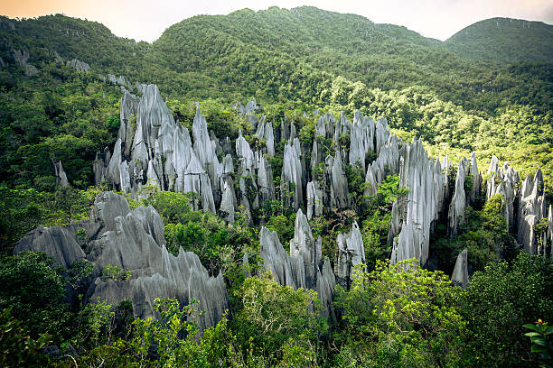
The surface expression of this geology is the Pinnacles of Mount Api. Located on the upper slopes of the mountain, this is an array of razor-sharp limestone blades protruding from the vegetated hillside, rising up to 45 metres in height . These are not stalagmites; they are the result of extreme differential solution weathering under acidic soil conditions. Rainwater, percolating through thick organic litter, becomes highly charged with carbonic and humic acids. As this water seeps through the joints and fractures of the limestone, it dissolves the carbonate rock along the fracture planes, leaving the more resistant, dense sections standing in relief. Over millennia, this etching process has created a landscape that resembles a petrified forest of stone daggers, a terrain so sharp that it can shred standard hiking boots and skin with equal ease.

Beneath the surface, the Clearwater Cave System exemplifies ongoing geological processes. As of 2018, the surveyed length of the Clearwater system exceeded 227 kilometres, making it the longest cave system in Southeast Asia and one of the longest in the world . The system is a complex, multi-level labyrinth that integrates the waters of several distinct river systems. The connection of Clearwater Cave to the Cave of the Winds in 1988, and subsequently to Blackrock Cave in 1991 and Whiterock Cave in 2005, demonstrated the immense lateral extent of the Melinau aquifer . These connections provided crucial evidence for understanding the regional groundwater flow patterns. The cave contains active underground rivers that can be navigated by boat for significant distances, as well as fossil passages decorated with massive calcite formations. The presence of giant collapse dolines such as the Garden of Eden punches windows through the cave roof, allowing primary rainforest to establish deep within the karst massif, creating a unique ecotone between the sunless underworld and the canopy above.
Criterion (ix): Ongoing Biological and Ecological Processes
The ecology of the Mulu caves provides an outstanding natural laboratory for studying biological evolution and ecological adaptation. Criterion (ix) recognises sites that are significant for ongoing biological processes, and Mulu’s subterranean ecosystems are arguably its most scientifically valuable biological asset.
The caves host over 200 species of cave-adapted fauna (troglobites), many of which exhibit extreme morphological adaptation to perpetual darkness . These include complete loss of pigmentation (depigmentation), elongation of appendages to maximise sensory input in the absence of light, and the total regression of optical structures. Notably, many of Mulu's troglobites belong to relict phylogenetic lineages—groups of organisms that were widespread on the surface millions of years ago but have since been outcompeted in the epigean (surface) environment. The caves have acted as climatic refugia, preserving "living fossils" that have disappeared from the surface landscapes of Borneo. The food web of these caves is almost entirely dependent on allochthonous energy input—organic material brought in from the surface. The primary vectors for this energy are the bat guano deposited in massive quantities beneath the roosts and the nests of swiftlets . This creates a unique ecological cascade: the productivity of the surrounding dipterocarp forest, which supports the insect biomass, directly dictates the health of the cave ecosystem 200 metres underground.
Above ground, the park exhibits seventeen distinct vegetation zones, compressed into a relatively small altitudinal range from lowland alluvial flats to the mossy, cloud-wreathed summit of Mount Mulu . This compression is a result of the steep topographic gradient and the rapid change in soil chemistry from acidic sandstone to alkaline limestone. The limestone cliffs support a specialised flora capable of surviving on near-vertical, nutrient-poor surfaces, including several endemic species of pitcher plants (Nepenthes lowii, N. tentaculata, and the Mount Mulu endemic N. muluensis) . The one-leaf plant (Monophyllaea pendula), found in the moist crevices of the mossy forest, represents a unique morphological adaptation where the entire plant consists of a single, massive cotyledon (seed leaf) that persists for the life of the organism.
Criterion (x): In-situ Conservation of Biodiversity
The final criterion for UNESCO inscription addresses the direct conservation of biodiversity. Mulu is recognised as one of the richest assemblages of flora and fauna in any area of comparable size globally. Botanical surveys have catalogued approximately 3,500 species of vascular plants, 1,700 species of mosses and liverworts, and over 4,000 species of fungi .
The park is particularly significant for its palm flora. It is considered one of the richest sites in the world for palm species, with 109 species spanning twenty genera documented within the park boundaries . This diversity reflects the heterogeneity of habitats available; different palm species occupy distinct niches ranging from the flood-prone riparian zones, through the shaded dipterocarp forest understorey, to the exposed, windswept ridges of the upper montane zone. Many of these are endemic to Borneo, and several are restricted entirely to the Mulu massif.
The faunal diversity is equally impressive. The checklist includes 81 species of mammals, 270 species of birds, 55 species of reptiles, 76 species of amphibians, and 48 species of fish . Among the mammals, the park provides critical habitat for several species listed on the IUCN Red List of Threatened Species. These include the Bornean gibbon (Hylobates muelleri), the Sunda clouded leopard (Neofelis diardi subsp. borneensis), and the extremely rare and enigmatic Bay cat (Catopuma badia), one of the least known felids in the world, which is endemic to the island of Borneo . The presence of the world's smallest mammal, the Savi’s pygmy shrew (Suncus etruscus), with a body mass of approximately 2 grams, highlights the exceptional range of body sizes and ecological niches encompassed within the park.
The invertebrate fauna is hyper-diverse. An estimated 20,000 species of invertebrates inhabit the park, including 281 species of butterflies and 458 species of ants . These invertebrate communities are the engine of the forest, driving pollination, decomposition, and nutrient cycling. The unique relationship between the pitcher plant Nepenthes lowii and the mountain shrew (Tupaia montana) is a notable example of mutualism; the shrew feeds on nectar produced by the pitcher lid, and defecates into the pitcher, providing the plant with its primary source of nitrogen in the nutrient-stressed montane environment . Similarly, the frog Philautus sp. has evolved to breed exclusively in the fluid-filled pitchers of Nepenthes, a reproductive strategy documented nowhere else on Earth.
Human History and the Legacy of Scientific Exploration
The recognition of these values did not occur overnight. The recorded history of the Mulu caves began with Spenser St. John, the British Consul to Brunei, who in 1858 noted the presence of "detached masses of limestone, much water-worn, with caverns and natural tunnels" in his writings . However, it was the Royal Geographical Society Expedition of 1977-1978 that fundamentally transformed Mulu from a geographical curiosity into a world-class scientific asset. This expedition was the largest ever dispatched from the United Kingdom, involving over 100 scientists operating in the field for 15 continuous months . Using the Long Pala base camp, accessible only by a three-day upriver boat journey from Miri, the team surveyed 50 kilometres of cave passages, including the initial sections of Clearwater Cave, Green Cave, Wonder Cave, and Prediction Cave.
Subsequent expeditions throughout the 1980s and 1990s, conducted under the banner of the Mulu Caves Project, systematically unveiled the scale of the system. The discovery of the Sarawak Chamber by a British team in December 1980 was a landmark moment in speleological history. In 1988, the connection of Clearwater Cave to the Cave of the Winds created Southeast Asia's longest cave; in 1991, the link to Blackrock Cave propelled the system into the world's top ten . The pace of discovery has not slowed in the 21st century. The discovery of Whiterock Cave in 2003 and its subsequent connection to the Clearwater System in 2005 extended the system to 129.4 kilometres. By 2017, ongoing exploration had pushed this figure to 226.3 kilometres . This trajectory of continuous discovery is central to Mulu's World Heritage status; it is a living laboratory where the total known extent of the resource is still expanding.
Conservation Outlook and Contemporary Management
Despite its UNESCO status and remote location, Gunung Mulu National Park is not immune to anthropogenic pressure. The 2025 Conservation Outlook Assessment, finalised by the IUCN in October 2025, rated the site as having "Good with some concerns" . This rating reflects a nuanced reality: the core geological values remain in pristine condition, but the surrounding socio-ecological system is under increasing strain.
The primary threat identified is not tourism itself, but the uncontrolled urbanisation and rapid population growth occurring along the park's western boundary. This is exacerbated by the anticipated construction of a highway connecting the coastal city of Miri directly to the park's boundary . While intended to boost regional economic activity and visitor numbers, the road risks stimulating an uncontrollable influx of migrants seeking economic opportunity, leading to unplanned settlement and an intensification of resource extraction. Currently, the park is accessible only by air via MASwings flights from Miri, Kuching, or Kota Kinabalu, a logistical constraint that has historically limited visitor numbers and provided a de facto buffer against mass tourism.
Illegal hunting is identified as a significant and increasing threat. While subsistence hunting of wild boar and deer by indigenous communities with customary rights is permitted in specified zones, there is evidence of widespread illegal hunting by migrant populations without such privileges. These hunters are reportedly targeting any species perceived as edible or saleable, extending their activities into prohibited zones and potentially impacting populations of threatened species such as the Clouded leopard and various primates .
Management of the park is administratively split between two entities. The Sarawak Forestry Corporation (SFC) retains overall responsibility for the conservation and protection of the entire 52,864-hectare property. However, the tourism services and visitor infrastructure within the show caves and park headquarters are managed by Borsarmulu Park Management Sdn. Bhd., a Government-Linked Company owned by the Sarawak Economic Development Corporation . This public-private partnership model has been effective in delivering high-quality visitor experiences but raises concerns regarding the capacity to manage the anticipated surge in visitation without a scientifically determined carrying capacity for sensitive cave environments.
Furthermore, recent academic research highlights a critical social dimension to conservation. A 2024 study published by Springer revealed significant gaps in "species literacy" among both local communities and visitors regarding the threatened species of Mulu . The study found that while respondents had a high-level understanding of biodiversity concepts, their ability to identify specific IUCN Red List species and understand their conservation status was limited. This knowledge gap poses a risk; ignorance of a species' rarity correlates with a lack of support for its protection. The study recommends targeted environmental education programs to foster a stewardship ethic capable of supporting formal management regulations.
Conclusion
Gunung Mulu National Park is not merely a collection of large caves; it is a complete and legible record of planetary processes operating over deep time. It satisfies the UNESCO World Heritage criteria not through a single outstanding feature, but through the intersection of four distinct global values. The surface and underground karst provides a textbook example of tropical geomorphological evolution, preserving evidence of tectonic pulses and Pleistocene climatic cycles within its multi-tiered passages [criterion viii]. The caves themselves are vessels of superlative natural phenomena, containing the planet's largest chamber and largest cave passage, and hosting one of its most dramatic biomass migrations [criterion vii]. The biological communities within these caves represent an ongoing evolutionary experiment in adaptation to extreme environments, preserving ancient lineages long extinct on the surface [criterion ix]. Finally, the surrounding rainforest represents a globally significant reservoir of biodiversity, supporting endemic palms, carnivorous plants, and a suite of rare and elusive vertebrate species [criterion x].
As of 2025, the park stands at a crossroads. Its core geological and speleological values remain intact, protected by rugged terrain and a strong legislative framework. Yet the pressures of regional development, demographic change, and climate variability are escalating. The successful long-term conservation of Mulu will depend not on the construction of physical barriers, but on the bridging of knowledge gaps, the strengthening of management capacity, and the maintenance of the delicate equilibrium between scientific discovery, sustainable tourism, and the rights and needs of the indigenous communities for whom this landscape has been home for millennia. The title of World Heritage Site confers prestige, but its true purpose is the contract of perpetual protection it implies. For Gunung Mulu, honouring that contract remains an ongoing and urgent endeavour.
Photo from iStock
0 Comment to "Gunung Mulu National Park, Malaysia : A UNESCO World Heritage Synthesis of Tropical Karst, Mega-Caves, Biodiversity and Geological Time"
Post a Comment